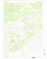
1967 Map of Twin Mountains
USGS Topo · Published 1980About this map
Rio Grande National Forest defines this high-elevation landscape in Saguache County, where the southern reaches of the La Garita Mountains meet the San Luis Valley's edge. This 1967 field check documents a wilderness shaped by livestock and water management, evidenced by the prominent Stock Driveway and a network of named springs like Usevia Springs and Sunday Spring. The terrain is characterized by geological landmarks such as the Natural Arch and the namesake Twin Mountains, rising above a complex system of drainages including Old Woman Creek and Little La Garita Creek. While largely protected forest land, the map records industrial potential through several Prospects located in the southwestern quadrant. The lack of improved roads and the reliance on a Jeep Trail or Pack Trail underscore the area's isolation and its primary role as a rugged watershed and grazing range during the mid-20th century.
Find a feature on this map
25 named features on this map. Tap any name to fly to it.
Don’t see what you’re looking for? This feature index may not catch every label — zoom into the map to look around manually.
Map Details
Editions of this 1967 Twin Mountains Map
4 editions found
Other maps of this area

1914 · Creede
USGS Topo · 1:125,000

1915 · Del Norte
USGS Topo · 1:125,000

1916 · Creede
USGS Topo · 1:125,000

1917 · Del Norte
USGS Topo · 1:125,000

1945 · Durango
USGS Topo · 1:250,000

1953 · Durango
USGS Topo · 1:250,000

1954 · Durango
USGS Topo · 1:250,000

1961 · Durango
USGS Topo · 1:250,000

1963 · Durango
USGS Topo · 1:250,000

1966 · Durango
USGS Topo · 1:250,000