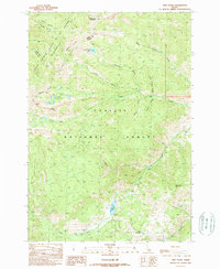
1989 Map of Twin Peaks
USGS Topo · Published 1989About this map
The high ridges of Twin Peaks dominate this 1980s topographic landscape, situated along the boundary of Lemhi and Custer Counties. This terrain is characterized by the expansive Challis National Forest and the protected acreage of the Frank Church River of No Return Wilderness. The map captures a high-altitude network of drainage systems, including Challis Creek and the headwaters of Bear Creek, which feed into Mosquito Flat Reservoir in the southern portion of the quadrangle.
Find a feature on this map
27 named features on this map. Tap any name to fly to it.
Don’t see what you’re looking for? This feature index may not catch every label — zoom into the map to look around manually.
Map Details
Editions of this 1989 Twin Peaks Map
This is the sole edition of this map. No revisions or reprints were ever made.
Other maps of this area

1919 · Custer
USGS Topo · 1:125,000

1922 · Custer
USGS Topo · 1:125,000

1929 · Bayhorse
USGS Topo · 1:125,000

1930 · Casto
USGS Topo · 1:125,000

1956 · Twin Peaks
USGS Topo · 1:62,500

1957 · Challis
USGS Topo · 1:250,000

1960 · Challis
USGS Topo · 1:250,000

1963 · Challis
USGS Topo · 1:250,000

1963 · Challis Creek Lakes
USGS Topo · 1:24,000

1963 · Bayhorse Lake
USGS Topo · 1:24,000