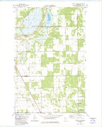
1982 Map of Twistal Swamp
USGS Topo · Published 1982About this map
Twistal Swamp dominates this northern Minnesota landscape, where the wetland topography of A R V E S O N and L I N C O L N townships was significantly altered by the drainage efforts of the early 20th century. The presence of Lateral Ditch No 5 and the channelization near the Tamarac River illustrate the massive hydraulic engineering undertaken to manage the water table for agriculture and conservation. This survey, compiled in the late 1970s and early 1980s, shows the intersection of these reclaimed lands with established community landmarks like the Townhall and the Zion Ch. Large portions of the quadrangle are dedicated to conservation, including the Twin Lakes State Wildlife Management Area and the East Park State Wildlife Management Area, preserving habitat around South Twin Lake. The map also captures local industry through scattered Gravel Pit locations and a prominent Radio Tower in the west.
Find a feature on this map
17 named features on this map. Tap any name to fly to it.
Don’t see what you’re looking for? This feature index may not catch every label — zoom into the map to look around manually.
Map Details
Editions of this 1982 Twistal Swamp Map
This is the sole edition of this map. No revisions or reprints were ever made.
Other maps of this area

1919 · Pelan
USGS Topo · 1:62,500

1952 · Thief River Falls
USGS Topo · 1:250,000

1956 · Thief River Falls
USGS Topo · 1:250,000

1956 · Karlstad
USGS Topo · 1:62,500

1956 · Florian
USGS Topo · 1:62,500

1957 · Thief River Falls
USGS Topo · 1:250,000

1957 · Newfolden
USGS Topo · 1:62,500

1957 · Pelan
USGS Topo · 1:62,500

1967 · Thief River Falls
USGS Topo · 1:250,000
1982 · Pelan
USGS Topo · 1:24,000