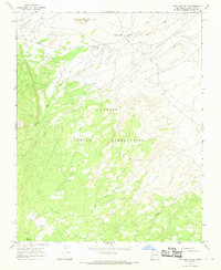
1966 Map of Two Grey Hills
USGS Topo · Published 1969About this map
The Navajo Indian Reservation landscape is defined by the prominent Grey Mesa and the distinct formation of Two Grey Hills in the mid-1960s. This desert environment is etched with a network of seasonal drainages, including Two Grey Hills Wash, Captain Tom Wash, and Tunisa Wash, which converge as they flow across the arid terrain. Human presence is indicated by a scattered network of unimproved roads and several water sources vital for life in this part of San Juan County, such as Mormon Spring and a lonely Well located on the flats below the mesa. A small Cem is marked near the northwestern corner, serving as a quiet genealogical marker for the local community. The mapping reveals a land of high plateaus and alluvial washes where the survival of early inhabitants relied on these few named springs and watercourses.
Find a feature on this map
11 named features on this map. Tap any name to fly to it.
Don’t see what you’re looking for? This feature index may not catch every label — zoom into the map to look around manually.
Map Details
Editions of this 1966 Two Grey Hills Map
2 editions found
Other maps of this area

1889 · Chaco
USGS Topo · 1:250,000

1892 · Chaco
USGS Topo · 1:250,000

1927 · Sulphur Spring
USGS Topo · 1:96,000

1928 · Kirtland
USGS Topo · 1:125,000

1932 · Kirtland
USGS Topo · 1:125,000

1953 · Sanostee
USGS Topo · 1:62,500

1954 · Shiprock
USGS Topo · 1:250,000

1958 · Shiprock
USGS Topo · 1:250,000

1959 · Shiprock
USGS Topo · 1:250,000
1966 · Sheep Springs
USGS Topo · 1:24,000
Featured Places
- Shiprock Agency
- Two Grey Hills, Shiprock Agency
- Kin Łizhin, Shiprock Agency
- San Juan County, NM
- United States