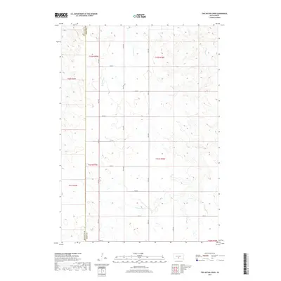
2017 Map of Two Nation Creek
USGS Topo · Published 2017About this map
Two Nation Creek meanders through the drainages of the South Dakota prairie, forming a focal point for this landscape along the border of Mellette and Tripp counties. The area is defined by a grid of rural section-line roads, including 297th Ave and 267th St, which trace the high ground between intermittent waterways. This 2017 survey illustrates the persistent agricultural and ranching patterns of the region, where the terrain is shaped by the watersheds of Little Dog Creek and Cottonwood Creek. The sparse distribution of named features highlights a primarily open, working landscape where the land use remains dictated by the natural draws and creek beds that break up the upland plains.
Find a feature on this map
23 named features on this map. Tap any name to fly to it.
Don’t see what you’re looking for? This feature index may not catch every label — zoom into the map to look around manually.
Map Details
Editions of this 2017 Two Nation Creek Map
This is the sole edition of this map. No revisions or reprints were ever made.
Other maps of this area

1951 · Badnation
USGS Topo · 1:24,000

1951 · Presho 4 NE
USGS Topo · 1:24,000

1951 · Presho 4 NW
USGS Topo · 1:24,000

1955 · Martin
USGS Topo · 1:250,000

1958 · Martin
USGS Topo · 1:250,000

1982 · Presho 4 SE
USGS Topo · 1:25,000

1982 · Two Nation Creek
USGS Topo · 1:25,000

1982 · Badnation SE
USGS Topo · 1:25,000

1982 · Witten
USGS Topo · 1:25,000
1982 · Carter
USGS Topo · 1:25,000