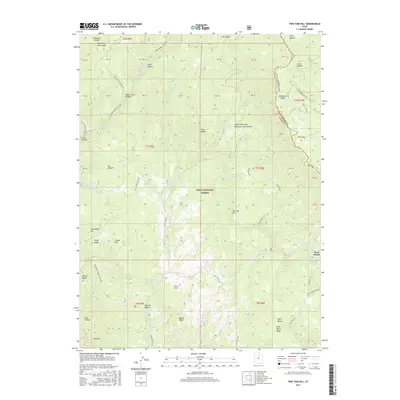
2017 Map of Two Tom Hill
USGS Topo · Published 2017About this map
Uinta National Forest dominates this mountainous landscape within the Wasatch Range, where the boundary between Wasatch and Utah Counties follows the high ground of Strawberry Ridge. The terrain is deeply incised by drainages such as Diamond Fork and Sixth Water Creek, the latter descending from the prominent Sixth Water Divide. A notable human imprint on this wilder terrain is the Ruby Christensen Memorial Youth Forest, located near the northern edge. The map captures a transition in water management and transport, marked by the presence of West Portal in the southeast. While much of the area remains undeveloped forest land, the network of tracks like Diamond Fork Road and Rays Valley Road provides access to remote landmarks like Mollies Nipple, Two Tom Hill, and the pastoral Farmer Slope.
Find a feature on this map
55 named features on this map. Tap any name to fly to it.
Don’t see what you’re looking for? This feature index may not catch every label — zoom into the map to look around manually.
Map Details
Editions of this 2017 Two Tom Hill Map
This is the sole edition of this map. No revisions or reprints were ever made.
Other maps of this area

1885 · Salt Lake
USGS Topo · 1:250,000

1907 · Strawberry Valley
USGS Topo · 1:125,000

1909 · Strawberry Valley
USGS Topo · 1:125,000

1954 · Salt Lake City
USGS Topo · 1:250,000

1958 · Salt Lake City
USGS Topo · 1:250,000

1960 · Salt Lake City
USGS Topo · 1:250,000

1966 · Strawberry Reservoir NW
USGS Topo · 1:24,000
1966 · Strawberry Reservoir SW
USGS Topo · 1:24,000

1967 · Two Tom Hill
USGS Topo · 1:24,000
1967 · Granger Mtn
USGS Topo · 1:24,000