
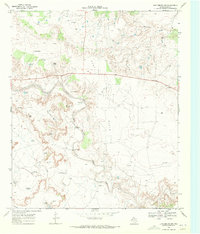
1962 Map of Twomile Creek
USGS Topo · Published 1963About this map
The confluence of the Salt Fork Brazos River and its western tributaries dominates this early 1960s survey of the West Texas caprock country. The landscape is defined by ranching infrastructure and hydrological management in a semi-arid environment, with numerous man-made water catchments such as Twomile Tank, Red Arroyo Tank, and Kay Tank scattered across the terrain.
Find a feature on this map
14 named features on this map. Tap any name to fly to it.
Don’t see what you’re looking for? This feature index may not catch every label — zoom into the map to look around manually.
Map Details
Editions of this 1962 Twomile Creek Map
This is the sole edition of this map. No revisions or reprints were ever made.
Other maps of this area

1954 · Lubbock
USGS Topo · 1:250,000

1962 · Smith Tank
USGS Topo · 1:24,000

1966 · Kalgary
USGS Topo · 1:24,000

1967 · Spur NW
USGS Topo · 1:24,000

1968 · Spur SW
USGS Topo · 1:24,000

1969 · Verbena
USGS Topo · 1:24,000

1969 · Cottonwood Creek
USGS Topo · 1:24,000
1969 · Justiceburg NW
USGS Topo · 1:24,000

1969 · T-O Creek
USGS Topo · 1:24,000
1985 · Aspermont
USGS Topo · 1:100,000