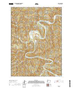
2020 Map of Tyee
USGS Topo · Published 2020About this map
The Umpqua River carves a deep, serpentine path through this section of Douglas County, defining the local topography with dramatic bends and riverside features. Small settlements like Tyee and Millwood serve as focal points for a landscape marked by steep ridges and narrow valleys. River-formed landmarks such as Powell Bar, Branton Bar, and the protected Myrtle Island illustrate the historic role of the river in shaping the habitable land.
Find a feature on this map
72 named features on this map. Tap any name to fly to it.
Don’t see what you’re looking for? This feature index may not catch every label — zoom into the map to look around manually.
Map Details
Editions of this 2020 Tyee Map
This is the sole edition of this map. No revisions or reprints were ever made.
Other maps of this area

1897 · Roseburg
USGS Topo · 1:125,000

1900 · Roseburg
USGS Topo · 1:125,000

1928 · Sitkum
USGS Topo · 1:125,000

1954 · Sutherlin
USGS Topo · 1:62,500

1954 · Drain
USGS Topo · 1:62,500

1955 · Tyee
USGS Topo · 1:62,500

1955 · Elkton
USGS Topo · 1:62,500

1958 · Roseburg
USGS Topo · 1:250,000

1959 · Roseburg
USGS Topo · 1:250,000

1979 · Roseburg
USGS Topo · 1:100,000