1949 Map of Tyler
USGS Topo · Published 1949About this map
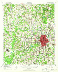
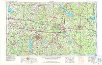
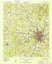
The city of Tyler serves as the focal point of this 1949 study, showing a bustling regional center defined by its early mid-century infrastructure and educational institutions. Within the city, Texas College and Junior College are clearly visible, while the industrial and transit footprint is marked by the intersecting lines of the Missouri Pacific and St Louis Southwestern railroads. To the northeast, the recreational landscape of Tyler State Park surrounds Beauchamp Springs, providing a contrast to the agricultural and research activities at the State Agricultural Experiment Sta near Thedford.
Find a feature on this map
88 named features on this map. Tap any name to fly to it.
Don’t see what you’re looking for? This feature index may not catch every label — zoom into the map to look around manually.
Map Details
Editions of this 1949 Tyler Map
This is the sole edition of this map. No revisions or reprints were ever made.
Historical Maps of Tyler Through Time
6 maps found