
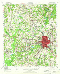
1948 Map of Tyler
USGS Topo · Published 1964About this map
The city of Tyler serves as a thriving hub of East Texas in the late 1940s, anchored by a dense network of institutional and transport landmarks. The landscape is defined by the intersection of the Missouri Pacific and St Louis Southwestern railroads, which facilitated the region's agricultural and industrial output. Educational and civic life is prominent, evidenced by Texas College and numerous rural schoolhouses like Dixie Sch and Young Hill Sch. To the northeast, the grounds of Tyler State Park and the historic site of Camp Ford offer a view into the area's recreational and Civil War-era significance.
Find a feature on this map
81 named features on this map. Tap any name to fly to it.
Don’t see what you’re looking for? This feature index may not catch every label — zoom into the map to look around manually.
Map Details
Editions of this 1948 Tyler Map
2 editions found
Other maps of this area

1937 · Troupe
USGS Topo · 1:48,000

1938 · Winona
USGS Topo · 1:48,000

1943 · Troup
USGS Topo · 1:62,500

1943 · Winona
USGS Topo · 1:62,500

1946 · Bullard
USGS Topo · 1:62,500

1948 · Bullard
USGS Topo · 1:62,500

1948 · Brownsboro
USGS Topo · 1:62,500

1949 · Tyler
USGS Topo · 1:62,500

1949 · Brownsboro
USGS Topo · 1:62,500

1949 · Frankston
USGS Topo · 1:62,500