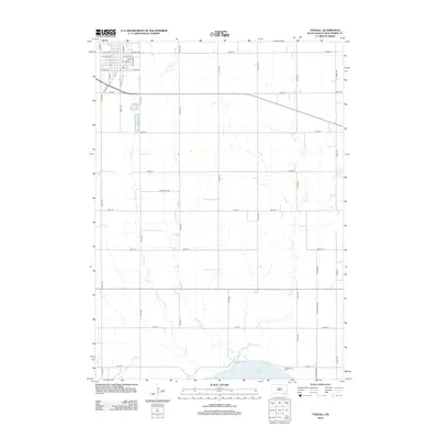
2012 Map of Tyndall
USGS Topo · Published 2012About this map
Bon Homme Colony and the nearby Bon Homme Cem anchor the southeastern corner of this landscape, situated just north of the expansive Lewis and Clark Lake. The topography is defined by several drainage systems moving southward toward the Missouri River reservoir, including the winding paths of Silver Creek, Deadman Creek, and Snatch Creek. The northern portion of the map is dominated by the street grid of Tyndall, where prominent thoroughfares like Main St and Pearl Rd provide a structured contrast to the surrounding section lines.
Find a feature on this map
42 named features on this map. Tap any name to fly to it.
Don’t see what you’re looking for? This feature index may not catch every label — zoom into the map to look around manually.
Map Details
Editions of this 2012 Tyndall Map
This is the sole edition of this map. No revisions or reprints were ever made.
Other maps of this area

1898 · Olivet
USGS Topo · 1:125,000

1955 · Sioux City
USGS Topo · 1:250,000

1955 · Sioux Falls
USGS Topo · 1:250,000

1958 · Sioux City
USGS Topo · 1:250,000

1958 · Sioux Falls
USGS Topo · 1:250,000

1959 · Sioux City
USGS Topo · 1:250,000

1974 · Bon Homme Colony
USGS Topo · 1:24,000
1977 · Springfield
USGS Topo · 1:24,000

1978 · Tripp SE
USGS Topo · 1:24,000
1978 · Santee
USGS Topo · 1:24,000
Featured Places
- Tyndall, SD
- Bon Homme Township, SD
- Little Tabor Township, SD
- Springfield Township, SD
- Tabor Township, SD