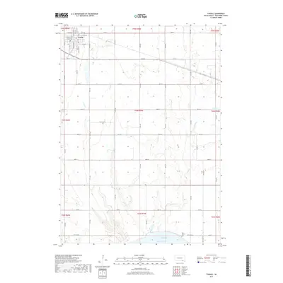
2017 Map of Tyndall
USGS Topo · Published 2017About this map
Tyndall serves as the primary hub of activity on this Bon Homme County landscape, situated amid a grid of section roads and drainage systems. The town is meticulously detailed down to its street grid, featuring W Main St, Pearl St, and S Baltimore Ave. To the south, the terrain slopes toward the Missouri River and the expansive Lewis and Clark Lake, where the shoreline is punctuated by local landmarks like the Bon Homme Cem. The landscape is defined by several key watercourses, including Snatch Cr, Deadman Cr, and Silver Cr, which carve through the agricultural sections. Smaller water bodies like Pechous Lake and the various rural roads like Apple Tree Rd and Cleveland Rd provide a clear view of the area's modern rural development and land use patterns.
Find a feature on this map
53 named features on this map. Tap any name to fly to it.
Don’t see what you’re looking for? This feature index may not catch every label — zoom into the map to look around manually.
Map Details
Editions of this 2017 Tyndall Map
This is the sole edition of this map. No revisions or reprints were ever made.
Other maps of this area

1898 · Olivet
USGS Topo · 1:125,000

1955 · Sioux City
USGS Topo · 1:250,000

1955 · Sioux Falls
USGS Topo · 1:250,000

1958 · Sioux City
USGS Topo · 1:250,000

1958 · Sioux Falls
USGS Topo · 1:250,000

1959 · Sioux City
USGS Topo · 1:250,000

1974 · Bon Homme Colony
USGS Topo · 1:24,000
1977 · Springfield
USGS Topo · 1:24,000

1978 · Tripp SE
USGS Topo · 1:24,000
1978 · Santee
USGS Topo · 1:24,000
Featured Places
- Tyndall, SD
- Bon Homme Township, SD
- Little Tabor Township, SD
- Springfield Township, SD
- Tabor Township, SD