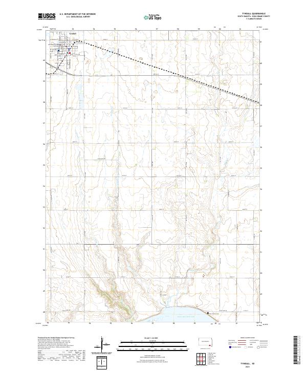
2021 Map of Tyndall
USGS Topo · Published 2021About this map
The city of Tyndall serves as the focal point of this Bon Homme County landscape, anchored by the Bon Homme County Courthouse and a rigid grid of streets including Main St and S Baltimore Ave. The geography is defined by a series of south-flowing drainages, notably Deadman Cr, Silver Cr, and Snatch Creek, which carve through the plains toward the Missouri River basin. In the south, the terrain meets the northern reaches of Lewis and Clark Lake, a significant reservoir that reshaped the local topography following mid-century dam projects. This map illustrates the intersection of rural agriculture and small-town administration, with a network of section-line roads like Apple Tree Rd and Pearl Rd connecting outlying farmsteads to the county seat and the Bon Homme Cem near the shoreline.
Find a feature on this map
47 named features on this map. Tap any name to fly to it.
Don’t see what you’re looking for? This feature index may not catch every label — zoom into the map to look around manually.
Map Details
Editions of this 2021 Tyndall Map
This is the sole edition of this map. No revisions or reprints were ever made.
Other maps of this area

1898 · Olivet
USGS Topo · 1:125,000

1955 · Sioux City
USGS Topo · 1:250,000

1955 · Sioux Falls
USGS Topo · 1:250,000

1958 · Sioux City
USGS Topo · 1:250,000

1958 · Sioux Falls
USGS Topo · 1:250,000

1959 · Sioux City
USGS Topo · 1:250,000

1974 · Bon Homme Colony
USGS Topo · 1:24,000
1977 · Springfield
USGS Topo · 1:24,000

1978 · Tripp SE
USGS Topo · 1:24,000
1978 · Santee
USGS Topo · 1:24,000