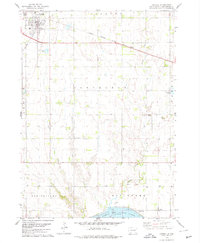
1978 Map of Tyndall
USGS Topo · Published 1979About this map
The railroad town of Tyndall serves as the focal point for this late-1970s survey, situated at the junction of the Chicago Milwaukee St Paul and Pacific railroad and a grid of rural section roads. The landscape transitions from the developed streets of the town into a series of drainages, including Silver Creek and Deadman Creek, which flow southward toward the Missouri River basin. In the southern portion of the map, the topography drops toward the expansive Lewis and Clark Lake, where underwater contours reflect the legacy of the Missouri River's flooded valley.
Find a feature on this map
22 named features on this map. Tap any name to fly to it.
Don’t see what you’re looking for? This feature index may not catch every label — zoom into the map to look around manually.
Map Details
Editions of this 1978 Tyndall Map
This is the sole edition of this map. No revisions or reprints were ever made.
Other maps of this area

1898 · Olivet
USGS Topo · 1:125,000

1955 · Sioux City
USGS Topo · 1:250,000

1955 · Sioux Falls
USGS Topo · 1:250,000

1958 · Sioux City
USGS Topo · 1:250,000

1958 · Sioux Falls
USGS Topo · 1:250,000

1959 · Sioux City
USGS Topo · 1:250,000

1974 · Bon Homme Colony
USGS Topo · 1:24,000
1977 · Springfield
USGS Topo · 1:24,000

1978 · Tripp SE
USGS Topo · 1:24,000
1978 · Santee
USGS Topo · 1:24,000