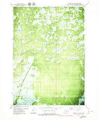
1979 Map of Tyonek B-1 NE
USGS Topo · Published 1980About this map
The Little Susitna River winds through a complex landscape of glacial deposits and wetlands in this 1970s orthophotomap of the Matanuska-Susitna region. The dominant geological feature is the Elmendorf Moraine, which shapes the distribution of numerous water bodies like Diamond Lake, Yohn Lake, and Carpenter Lake. This specific map format utilizes an orthophotomosaic to show actual vegetation patterns and terrain textures alongside traditional topographic data, revealing a territory primarily defined by its natural hydrology and limited human infrastructure.
Find a feature on this map
14 named features on this map. Tap any name to fly to it.
Don’t see what you’re looking for? This feature index may not catch every label — zoom into the map to look around manually.
Map Details
Editions of this 1979 Tyonek B-1 NE Map
2 editions found
Other maps of this area

1949 · Tyonek
USGS Topo · 1:250,000

1950 · Anchorage C-8
USGS Topo · 1:63,360

1951 · Anchorage
USGS Topo · 1:250,000

1951 · Tyonek
USGS Topo · 1:250,000

1952 · Anchorage C-8
USGS Topo · 1:63,360

1952 · Tyonek C-1
USGS Topo · 1:63,360

1952 · Anchorage B-8
USGS Topo · 1:63,360

1953 · Anchorage B-8
USGS Topo · 1:63,360

1958 · Tyonek B-1
USGS Topo · 1:63,360

1958 · Tyonek C-1
USGS Topo · 1:63,360