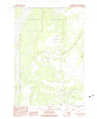
1983 Map of Tyonek D-1 SE
USGS Topo · Published 1983About this map
The Susitna River and its intricate network of tributaries dominate this landscape in the early 1980s, revealing a region defined by its complex hydrology and early transportation infrastructure. Braided channels and the Delta Islands characterize the river's path, while smaller water bodies like Kashwitna Lake and Willow Lake dot the lowlands. Near the settlement of Kashwitna, several tracks and a small Cem reflect local land use, while the Willow Airport and a nearby Landing Strip highlight the essential role of bush aviation in navigating this terrain. The drainage patterns of Little Willow Creek and Deception Creek illustrate the seasonal flow of water toward the larger Susitna valley, supporting a mix of small-scale infrastructure including a Gravel Pit and established tracks through the brush.
Find a feature on this map
20 named features on this map. Tap any name to fly to it.
Don’t see what you’re looking for? This feature index may not catch every label — zoom into the map to look around manually.
Map Details
Editions of this 1983 Tyonek D-1 SE Map
This is the sole edition of this map. No revisions or reprints were ever made.
Other maps of this area

1949 · Tyonek
USGS Topo · 1:250,000

1949 · Anchorage D-8
USGS Topo · 1:63,360

1950 · Anchorage C-8
USGS Topo · 1:63,360

1951 · Anchorage
USGS Topo · 1:250,000

1951 · Tyonek
USGS Topo · 1:250,000

1951 · Anchorage D-8
USGS Topo · 1:63,360

1952 · Anchorage C-8
USGS Topo · 1:63,360

1952 · Tyonek D-1
USGS Topo · 1:63,360

1952 · Tyonek C-1
USGS Topo · 1:63,360

1952 · Anchorage D-8
USGS Topo · 1:63,360