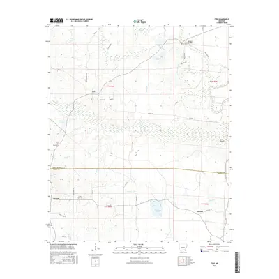
2017 Map of Tyro
USGS Topo · Published 2017About this map
Bayou Bartholomew snakes through the eastern edge of this landscape, marking a transition between the low-lying wetlands of the Delta and the rising terrain of the Arkansas interior. The settlement pattern is defined by rural crossroads and scattered homesteads, notably at Tyro and Garrett Bridge in the north, and Coleman and Florence further south. This 2017 survey details a region shaped by complex hydrology, from the broad expanse of Campbell Brake and Touchstone Prairie to various creeks like Ables Cr and Weaver Cr that feed the local drainage systems.
Find a feature on this map
49 named features on this map. Tap any name to fly to it.
Don’t see what you’re looking for? This feature index may not catch every label — zoom into the map to look around manually.
Map Details
Editions of this 2017 Tyro Map
This is the sole edition of this map. No revisions or reprints were ever made.
Other maps of this area

1935 · Feenyville
USGS Topo · 1:62,500

1935 · Cominto
USGS Topo · 1:62,500

1935 · Rotan
USGS Topo · 1:62,500

1953 · Greenwood
USGS Topo · 1:250,000

1956 · Greenwood
USGS Topo · 1:250,000

1960 · Selma
USGS Topo · 1:24,000

1960 · Collins NW
USGS Topo · 1:24,000

1960 · Collins
USGS Topo · 1:62,500
1964 · Avery
USGS Topo · 1:24,000
1964 · Gourd
USGS Topo · 1:24,000