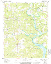
1968 Map of Udall
USGS Topo · Published 1986About this map
The North Fork Norfork Lake reservoir dominates the southeastern landscape of this Ozark County survey, marking the transition from riverine valley to a controlled waterway. Before the inundation reaches its full extent, the historical geography of the area is defined by the winding course of Bryant Creek and the North Fork Norfork Lake. This 1960s study captures the community of Tecumseh near the confluence and the landmark Dawt Mill further upstream, where the river's power was historically harnessed. The map provides significant genealogical value for the region, documenting several family and community landmarks such as Sallee Cem, Parker Cem, and Clear Springs Ch. The rugged topography, characterized by features like Tecumseh Ridge and Howards Ridge, illustrates the dispersed settlement patterns typical of this portion of the Missouri-Arkansas border region before modern development.
Find a feature on this map
51 named features on this map. Tap any name to fly to it.
Don’t see what you’re looking for? This feature index may not catch every label — zoom into the map to look around manually.
Map Details
Editions of this 1968 Udall Map
2 editions found
Other maps of this area

1890 · Mountain Home
USGS Topo · 1:125,000

1891 · Mountain Home
USGS Topo · 1:125,000

1894 · Mountain Home
USGS Topo · 1:125,000

1934 · Gainesville
USGS Topo · 1:48,000

1940 · Gainesville
USGS Topo · 1:62,500

1944 · Cureall
USGS Topo · 1:62,500

1945 · Harrison
USGS Topo · 1:250,000

1946 · Cureall
USGS Topo · 1:62,500

1949 · Harrison
USGS Topo · 1:250,000

1954 · Harrison
USGS Topo · 1:250,000