
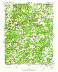
1944 Map of Cureall
USGS Topo · Published 1962About this map
Bakersfield and the rolling Ozark terrain of southern Missouri are mapped here during the mid-1940s, just as the rural landscape was shaped by a network of one-room schools and country churches. The geography is defined by the South Fork Spring River and Bennett Bayou, where river crossings like Double Spring Ford and Kelly Ford still facilitated local travel. Evidence of earlier industry persists at the Breakup Mill near Cureall and the Alice Mine to the west.
Find a feature on this map
106 named features on this map. Tap any name to fly to it.
Don’t see what you’re looking for? This feature index may not catch every label — zoom into the map to look around manually.
Map Details
Editions of this 1944 Cureall Map
2 editions found
Other maps of this area

1890 · Mountain Home
USGS Topo · 1:125,000

1891 · Mountain Home
USGS Topo · 1:125,000

1894 · Mountain Home
USGS Topo · 1:125,000

1934 · Gainesville
USGS Topo · 1:48,000

1937 · Buckhart
USGS Topo · 1:48,000

1939 · Topaz
USGS Topo · 1:62,500

1940 · Gainesville
USGS Topo · 1:62,500

1941 · Topaz
USGS Topo · 1:62,500

1943 · Buckhart
USGS Topo · 1:62,500

1944 · West Plains
USGS Topo · 1:62,500