
Loading...
Loading map...1943 Map of Ugashik
USGS Topo · Published 1962About this map
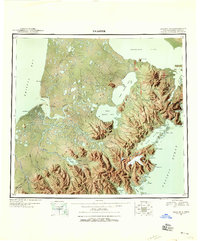
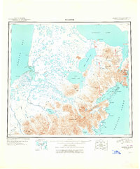
Pilot Point and the coastal waters of Ugashik Bay anchor this 1943 survey of the Alaska Peninsula, showcasing a landscape defined by its complex hydrology and volcanic peaks. The map details the transition from the low-lying wetlands of the west, drained by the Ugashik River and Dog Salmon River, to the dramatic elevations of the east. Significant inland water bodies like Upper Ugashik Lake, Lower Ugashik Lake, and the southern reaches of Becharof Lake dominate the central terrain.
Find a feature on this map
79 named features on this map. Tap any name to fly to it.
Don’t see what you’re looking for? This feature index may not catch every label — zoom into the map to look around manually.
Map Details
Date Portrayed1943
Date Published1962
PublisherU.S. Geological Survey
Map TypeTopographic
Scale1:250,000
Physical Dimensions22.5 x 27 inches
Editions of this 1943 Ugashik Map
3 editions found
Historical Maps of Pilot Point Through Time
4 maps found


Featured Locations
Source Details
SourceU.S. Geological Survey
CopyrightPublic Domain