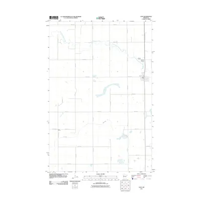
2011 Map of Ulen
USGS Topo · Published 2011About this map
Ulen stands as a primary focal point in this northwestern Minnesota landscape, where the town grid is clearly defined near the Ulen Post Office. The surrounding rural topography is shaped by the winding course of the South Branch Wild Rice River as it flows through the northern sections, while Felton Creek meanders across the southern portions of the sheet. For those researching family history in Clay County, the map provides precise locations for several local burial grounds, including the Sleeper Cemetery and Bethlehem Memorial Cemetery situated near the riverbanks, as well as Keene Cemetery to the west. A notable modern addition to the landscape is the Agassiz Recreational Trl, which follows a linear north-south path through the eastern part of the region, utilizing a corridor that historically facilitated movement through these prairie lands.
Find a feature on this map
25 named features on this map. Tap any name to fly to it.
Don’t see what you’re looking for? This feature index may not catch every label — zoom into the map to look around manually.
Map Details
Editions of this 2011 Ulen Map
This is the sole edition of this map. No revisions or reprints were ever made.
Other maps of this area

1918 · Flom
USGS Topo · 1:62,500

1918 · Ulen
USGS Topo · 1:62,500

1919 · Hawley
USGS Topo · 1:62,500

1952 · Grand Forks
USGS Topo · 1:250,000

1953 · Fargo
USGS Topo · 1:250,000

1956 · Fargo
USGS Topo · 1:250,000

1956 · Grand Forks
USGS Topo · 1:250,000

1965 · Syre
USGS Topo · 1:24,000
1965 · Ulen NW
USGS Topo · 1:24,000

1966 · Flom
USGS Topo · 1:24,000