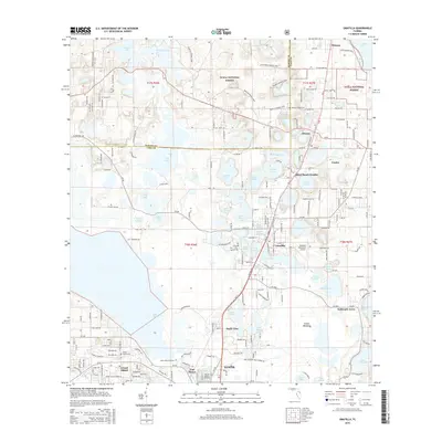
2015 Map of Umatilla
USGS Topo · Published 2015About this map
The town of Umatilla and the northern reaches of Eustis anchor this landscape characterized by dozens of freshwater lakes and the sprawling southern boundary of the Ocala National Forest. The geography is defined by its water, from large bodies like Lake Yale and Lake Umatilla to smaller isolated basins like Lake Tutuola and Lake Blanchester. The settlement pattern follows the north-south corridor of the rail line and highways, connecting hubs like Altoona and Dona Vista with historic markers like Fort Mason. Cultural and infrastructure landmarks are prominent, including the Umatilla Municipal Airport and Umatilla High School. Local history and genealogy are well-represented by several burial grounds, such as Altoona Hinson Cemetery and Lakeside Memory Gardens, while recreational spaces like Pine Meadows Golf Course and the Prairie Riding Loop in the forest show the transition toward a tourism-based economy.
Find a feature on this map
241 named features on this map. Tap any name to fly to it.
Don’t see what you’re looking for? This feature index may not catch every label — zoom into the map to look around manually.
Map Details
Editions of this 2015 Umatilla Map
This is the sole edition of this map. No revisions or reprints were ever made.
Other maps of this area

1954 · Daytona Beach
USGS Topo · 1:250,000

1955 · Orlando
USGS Topo · 1:250,000

1957 · Orlando
USGS Topo · 1:250,000

1958 · Orlando
USGS Topo · 1:250,000

1958 · Daytona Beach
USGS Topo · 1:250,000

1960 · Sorrento
USGS Topo · 1:24,000

1962 · Orlando
USGS Topo · 1:250,000

1964 · Daytona Beach
USGS Topo · 1:250,000

1965 · Leesburg East
USGS Topo · 1:24,000

1965 · Umatilla
USGS Topo · 1:24,000