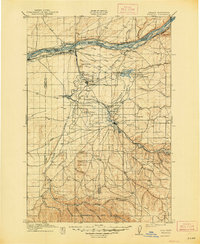
1908 Map of Umatilla
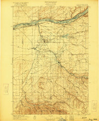
USGS Topo · Published 1948About this map
The Columbia River forms the northern boundary of this territory, where early 20th-century irrigation efforts began transforming the arid landscape. Evidence of these massive water projects is visible through the Oregon Land and Water Co Canal, the Furnish Ditch, and the creation of the Cold Springs Reservoir, which sits adjacent to the Cold Springs Bird Reservation. These engineering works supported growing settlements like Hermiston and Stanfield along the Umatilla River.
Find a feature on this map
65 named features on this map. Tap any name to fly to it.
Don’t see what you’re looking for? This feature index may not catch every label — zoom into the map to look around manually.
Map Details
Editions of this 1908 Umatilla Map
3 editions found
Other maps of this area

1906 · Blalock Island
USGS Topo · 1:125,000

1908 · Blalock Island
USGS Topo · 1:125,000

1908 · Umatilla
USGS Topo · 1:125,000

1915 · Wallulah
USGS Topo · 1:96,000

1915 · Prosser
USGS Topo · 1:125,000

1917 · Pasco
USGS Topo · 1:125,000

1917 · Prosser
USGS Topo · 1:125,000

1918 · Wallula
USGS Topo · 1:125,000

1935 · Pendleton
USGS Topo · 1:125,000

1953 · Pendleton
USGS Topo · 1:250,000