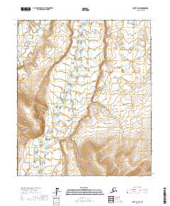
2017 Map of Umiat A-2 SW
USGS Topo · Published 2017About this map
Anaktuvuk River dominates this section of the Arctic landscape, carving a wide path northward through the North Slope. The river's braided channels and wide alluvial plains characterize the central terrain, bordered by the subtle elevations of the surrounding tundra. In the northwest corner, the Tuluga River flows through more confined valleys before eventually joining the larger watershed. This map captures the hydrography of the region in the early 21st century, showing the intricate network of lakes and seasonal wetlands that define the landscape between the t4s r4e and t5s r5e township boundaries. The lack of any man-made structures or roads emphasizes the isolation of this portion of the borough, where the shifting riverbeds are the most prominent geographical markers.
Find a feature on this map
6 named features on this map. Tap any name to fly to it.
Don’t see what you’re looking for? This feature index may not catch every label — zoom into the map to look around manually.
Map Details
Editions of this 2017 Umiat A-2 SW Map
This is the sole edition of this map. No revisions or reprints were ever made.
Other maps of this area

1951 · Chandler Lake
USGS Topo · 1:250,000

1952 · Umiat
USGS Topo · 1:250,000

1955 · Umiat A-3
USGS Topo · 1:63,360

1956 · Chandler Lake
USGS Topo · 1:250,000

1956 · Umiat
USGS Topo · 1:250,000

1964 · Chandler Lake
USGS Topo · 1:250,000

1964 · Umiat
USGS Topo · 1:250,000

1971 · Umiat A-2
USGS Topo · 1:63,360
1971 · Chandler Lake D-2
USGS Topo · 1:63,360
1987 · Chandler Lake D-3
USGS Topo · 1:63,360