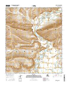
2016 Map of Umiat A-4 SE
USGS Topo · Published 2016About this map
The Chandler River carves a winding path through this portion of the North Slope, creating the distinctive topographic feature known as Big Bend. This 2016 survey captures the austere geometry of the Arctic landscape where the river meanders across wide, sediment-filled flats before meeting rising terrain. The lack of named settlements or roads emphasizes the isolation of this region within the North Slope Borough, where the primary markers are the surveying boundaries of T4s R1w, T4s R1e, T5s R1w, and T5s R1e. The intricate contour lines reveal the subtle elevation changes and drainage patterns that characterize this remote watershed, providing a foundation for understanding the natural movement of water across this sub-Arctic environment.
Find a feature on this map
6 named features on this map. Tap any name to fly to it.
Don’t see what you’re looking for? This feature index may not catch every label — zoom into the map to look around manually.
Map Details
Editions of this 2016 Umiat A-4 SE Map
This is the sole edition of this map. No revisions or reprints were ever made.
Other maps of this area

1951 · Chandler Lake
USGS Topo · 1:250,000

1952 · Umiat
USGS Topo · 1:250,000

1955 · Umiat A-4
USGS Topo · 1:63,360

1955 · Umiat A-3
USGS Topo · 1:63,360

1956 · Chandler Lake
USGS Topo · 1:250,000

1956 · Umiat
USGS Topo · 1:250,000

1964 · Chandler Lake
USGS Topo · 1:250,000

1964 · Umiat
USGS Topo · 1:250,000
1987 · Chandler Lake D-3
USGS Topo · 1:63,360
1987 · Chandler Lake D-4
USGS Topo · 1:63,360