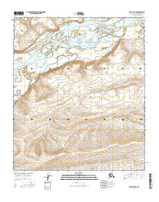
2016 Map of Umiat A-5 NW
USGS Topo · Published 2016About this map
The braided channels of the Colville River dominate the northern landscape of this North Slope region, illustrating the dynamic hydrology of the Alaskan Arctic. In this 2016 survey, the river system creates a complex network of gravel bars and shifting waterways as it moves through the expansive river valley. To the south, the terrain rises steadily toward the foothills, where Ninuluk Creek cuts through the uplands before joining the main river valley. The map provides a detailed view of the Public Land Survey System grid, showing the intersections of townships and ranges such as t2s r4w and t3s r4w. This specific geography highlights the transition from the broad, active alluvial plain to the higher, dissected ridges of the inland tundra, offering a clear picture of the natural drainage patterns in a remote part of the borough.
Find a feature on this map
11 named features on this map. Tap any name to fly to it.
Don’t see what you’re looking for? This feature index may not catch every label — zoom into the map to look around manually.
Map Details
Editions of this 2016 Umiat A-5 NW Map
This is the sole edition of this map. No revisions or reprints were ever made.
Other maps of this area

1951 · Ikpikpuk River
USGS Topo · 1:250,000

1952 · Umiat
USGS Topo · 1:250,000

1955 · Umiat A-5
USGS Topo · 1:63,360

1955 · Umiat B-5
USGS Topo · 1:63,360

1956 · Ikpikpuk River
USGS Topo · 1:250,000

1956 · Umiat
USGS Topo · 1:250,000

1964 · Umiat
USGS Topo · 1:250,000
1984 · Ikpikpuk River A-1
USGS Topo · 1:63,360
1985 · Ikpikpuk River B-1
USGS Topo · 1:63,360
2016 · Umiat B-5 SW
USGS Topo · 1:25,000