
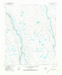
1955 Map of Umiat B-3
USGS Topo · Published 1971About this map
The confluence of major Arctic waterways defines this mid-century survey of the North Slope, where the Anaktuvuk River and Chandler River flow northward to meet the wide Colville River. This area represents a critical landscape of federal land management and early energy exploration, clearly marked by the Naval Petroleum Reserve No 4 Boundary and the presence of the Gubic Gas Field. Navigation and travel through this treeless terrain in 1955 relied heavily on a network of a Winter Trail, which threaded between the massive water bodies and prominent landmarks like Ulukrak Bluff and Shivugak Bluff. The drainage patterns of the Kutchik River and the isolated Kakiagun Lake illustrate the complex hydrology of the Alaskan tundra before modern industrial expansion.
Find a feature on this map
11 named features on this map. Tap any name to fly to it.
Don’t see what you’re looking for? This feature index may not catch every label — zoom into the map to look around manually.
Map Details
Editions of this 1955 Umiat B-3 Map
This is the sole edition of this map. No revisions or reprints were ever made.
Other maps of this area

1952 · Umiat
USGS Topo · 1:250,000

1955 · Umiat B-4
USGS Topo · 1:63,360

1955 · Umiat C-4
USGS Topo · 1:63,360

1955 · Umiat A-4
USGS Topo · 1:63,360

1955 · Umiat A-3
USGS Topo · 1:63,360

1955 · Umiat C-3
USGS Topo · 1:63,360

1956 · Umiat
USGS Topo · 1:250,000

1964 · Umiat
USGS Topo · 1:250,000

1971 · Umiat A-2
USGS Topo · 1:63,360
1971 · Umiat B-2
USGS Topo · 1:63,360