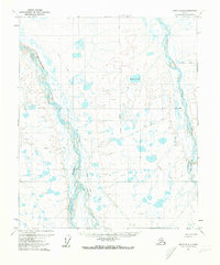
1971 Map of Umiat B-2
USGS Topo · Published 1973About this map
Braided river channels and Arctic tundra characterize this portion of the North Slope, where the Anaktuvuk River and Itkillik River dominate the landscape. In the early 1970s, this remote territory was mapped with an emphasis on terrain and temporary seasonal transit. The Winter Road and Winter Trail networks provide the only evidence of overland passage, cutting across the low-lying wet areas and around numerous small lakes. Specific topographic elevations bear unique names such as Paruk, Okpik, and Miriam, likely serving as essential orientation points in an otherwise repetitive environment of swamps and small water bodies like Square Lake. The inclusion of a Base Line and unsurveyed land lines reflects the Bureau of Land Management's ongoing efforts to organize these northern territories during a period of increased interest in the region's geography.
Find a feature on this map
13 named features on this map. Tap any name to fly to it.
Don’t see what you’re looking for? This feature index may not catch every label — zoom into the map to look around manually.
Map Details
Editions of this 1971 Umiat B-2 Map
This is the sole edition of this map. No revisions or reprints were ever made.
Other maps of this area

1952 · Umiat
USGS Topo · 1:250,000

1955 · Umiat A-3
USGS Topo · 1:63,360

1955 · Umiat C-3
USGS Topo · 1:63,360

1955 · Umiat B-3
USGS Topo · 1:63,360

1956 · Umiat
USGS Topo · 1:250,000

1964 · Umiat
USGS Topo · 1:250,000
1971 · Umiat C-1
USGS Topo · 1:63,360

1971 · Umiat A-2
USGS Topo · 1:63,360
1971 · Umiat A-1
USGS Topo · 1:63,360
1971 · Umiat C-2
USGS Topo · 1:63,360