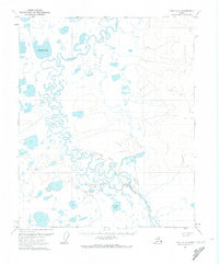
1971 Map of Umiat C-2
USGS Topo · Published 1974About this map
The Itkillik River winds through a landscape of countless thermokarst lakes and marshy lowlands in this remote Arctic survey. The terrain is characterized by a complex network of meandering watercourses and significant bodies of water such as Shirukak Lake in the north and Imaiknik Lake to the south. Small, isolated points of interest like Shirley, Bowl, and Shuk appear along the ephemeral transport routes that define travel in this region.
Find a feature on this map
9 named features on this map. Tap any name to fly to it.
Don’t see what you’re looking for? This feature index may not catch every label — zoom into the map to look around manually.
Map Details
Editions of this 1971 Umiat C-2 Map
This is the sole edition of this map. No revisions or reprints were ever made.
Other maps of this area

1952 · Umiat
USGS Topo · 1:250,000

1955 · Umiat D-2
USGS Topo · 1:63,360

1955 · Umiat D-3
USGS Topo · 1:63,360
1955 · Umiat D-1
USGS Topo · 1:63,360

1955 · Umiat C-3
USGS Topo · 1:63,360

1955 · Umiat B-3
USGS Topo · 1:63,360

1956 · Umiat
USGS Topo · 1:250,000

1964 · Umiat
USGS Topo · 1:250,000
1971 · Umiat C-1
USGS Topo · 1:63,360
1971 · Umiat B-2
USGS Topo · 1:63,360