
1955 Map of Umiat D-3
USGS Topo · Published 1971About this map
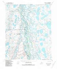
The Colville River carves a massive, braided path through this Arctic landscape, where the meandering Kogosukruk River and Kikiakrorak River feed into its expansive basin. The 1955 topography captures the North Slope in a state of primitive natural flux, characterized by a dense network of thaw lakes and ponds scattered across the tundra. Notable landmarks like Sentinel Hill and the prominent Ishukpak Bluff rise above the riverbanks, serving as vital orientation points in an otherwise low-lying wilderness. This region is significantly defined by its administrative status, as it sits within the Naval Petroleum Reserve No 4 Boundary, illustrating the mid-century strategic importance of Alaska's northern mineral and oil resources before the era of modern development.
Find a feature on this map
7 named features on this map. Tap any name to fly to it.
Don’t see what you’re looking for? This feature index may not catch every label — zoom into the map to look around manually.
Map Details
Editions of this 1955 Umiat D-3 Map
2 editions found
Other maps of this area

1951 · Harrison Bay
USGS Topo · 1:250,000

1952 · Umiat
USGS Topo · 1:250,000

1955 · Harrison Bay
USGS Topo · 1:250,000

1955 · Harrison Bay A-4
USGS Topo · 1:63,360

1955 · Umiat D-2
USGS Topo · 1:63,360

1955 · Harrison Bay A-2
USGS Topo · 1:63,360

1955 · Harrison Bay A-3
USGS Topo · 1:63,360

1955 · Umiat C-4
USGS Topo · 1:63,360
1955 · Umiat D-4
USGS Topo · 1:63,360

1955 · Umiat C-3
USGS Topo · 1:63,360