
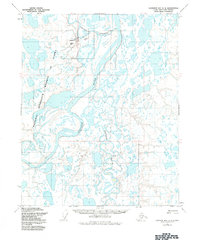
1955 Map of Harrison Bay A-2
USGS Topo · Published 1970About this map
The Colville River dominates this mid-century landscape of the North Slope, where the intricate delta systems of the Arctic coast begin to take shape. This 1955 survey captures a specific moment in the history of the Naval Petroleum Reserve No 4, showing the territory as it was managed by the Bureau of Land Management before extensive modern development. The terrain is a complex network of water and marshland, characterized by the winding Nechelik Channel and the southern confluence of the Itkillik River. Scattered throughout this water-logged expanse are small, isolated points of human activity labeled simply as Relays, Kinik, Flint, and Stone. These labels likely represent surveyor camps, navigational markers, or small indigenous sites used during the photogrammetric mapping process by the Army Map Service, providing a rare look at the early logistical footprint in this part of Alaska.
Find a feature on this map
9 named features on this map. Tap any name to fly to it.
Don’t see what you’re looking for? This feature index may not catch every label — zoom into the map to look around manually.
Map Details
Editions of this 1955 Harrison Bay A-2 Map
2 editions found
Other maps of this area

1951 · Harrison Bay
USGS Topo · 1:250,000

1952 · Umiat
USGS Topo · 1:250,000

1955 · Harrison Bay
USGS Topo · 1:250,000

1955 · Harrison Bay B-3
USGS Topo · 1:63,360

1955 · Harrison Bay B-2
USGS Topo · 1:63,360

1955 · Harrison Bay B-1
USGS Topo · 1:63,360

1955 · Umiat D-2
USGS Topo · 1:63,360

1955 · Harrison Bay A-3
USGS Topo · 1:63,360
1955 · Harrison Bay A-1
USGS Topo · 1:63,360

1955 · Umiat D-3
USGS Topo · 1:63,360