
1955 Map of Harrison Bay B-2
USGS Topo · Published 1967About this map
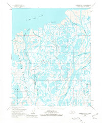
The Colville River Delta dominates this Arctic landscape, where a complex network of waterways like the Nechelik Channel and Kupigruak Channel branch out toward the Beaufort Sea. Captured in the mid-1950s, the terrain is characterized by intricate drainage patterns and coastal landforms such as Tolaktovut Point and Anajuk Point. Much of the western portion falls within the Naval Petroleum Reserve No 4, reflecting the strategic industrial interest in the North Slope's resources during the Cold War era. Significant landmarks include the curiously named Oil Lake and Kachemachi Mound, while the southeastern corner is defined by the Kachemach River. The presence of numerous Dunes along the channels suggests an environment of shifting sediments and high winds at the edge of Harrison Bay.
Find a feature on this map
15 named features on this map. Tap any name to fly to it.
Don’t see what you’re looking for? This feature index may not catch every label — zoom into the map to look around manually.
Map Details
Editions of this 1955 Harrison Bay B-2 Map
2 editions found
Other maps of this area

1951 · Harrison Bay
USGS Topo · 1:250,000

1955 · Harrison Bay
USGS Topo · 1:250,000

1955 · Harrison Bay C-1
USGS Topo · 1:63,360

1955 · Harrison Bay B-3
USGS Topo · 1:63,360
1955 · Harrison Bay C-3
USGS Topo · 1:63,360

1955 · Harrison Bay B-1
USGS Topo · 1:63,360

1955 · Harrison Bay A-2
USGS Topo · 1:63,360

1955 · Harrison Bay A-3
USGS Topo · 1:63,360
1955 · Harrison Bay A-1
USGS Topo · 1:63,360
1962 · Harrison Bay C-3
USGS Topo · 1:50,000