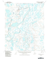
1955 Map of Harrison Bay A-2
USGS Topo · Published 1984About this map
The Colville River meanders through a landscape defined by water and oil exploration in this mid-century survey of the North Slope. Near the northern boundary, the settlement of Nuiqsut sits adjacent to the Nechelik Channel, served by a local Landing Strip. The map illustrates the early infrastructure of the National Petroleum Reserve in Alaska, including a solitary Oil Well and communication points like Relays. To the east, the Itkillik River winds through a dense network of lakes and marshes, joining the primary river system. This document reflects a period when indigenous settlement and resource exploration began to leave a permanent mark on the Arctic coastal plain, evidenced by the scattered presence of a Cabin and remote landmarks like Kinik.
Find a feature on this map
10 named features on this map. Tap any name to fly to it.
Don’t see what you’re looking for? This feature index may not catch every label — zoom into the map to look around manually.
Map Details
Editions of this 1955 Harrison Bay A-2 Map
2 editions found
Other maps of this area

1951 · Harrison Bay
USGS Topo · 1:250,000

1952 · Umiat
USGS Topo · 1:250,000

1955 · Harrison Bay
USGS Topo · 1:250,000

1955 · Harrison Bay B-3
USGS Topo · 1:63,360

1955 · Harrison Bay B-2
USGS Topo · 1:63,360

1955 · Harrison Bay B-1
USGS Topo · 1:63,360

1955 · Umiat D-2
USGS Topo · 1:63,360

1955 · Harrison Bay A-2
USGS Topo · 1:63,360

1955 · Harrison Bay A-3
USGS Topo · 1:63,360
1955 · Harrison Bay A-1
USGS Topo · 1:63,360