
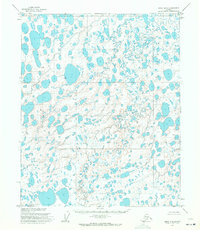
1955 Map of Harrison Bay A-4
USGS Topo · Published 1964About this map
Naval Petroleum Reserve No. 4 encompasses this entire Arctic landscape, defined by a labyrinthine network of thaw lakes and wandering watercourses. The hydrology of the region is dominated by the intricate meanders of Fish Creek and Judy Creek, which carve through the tundra with numerous oxbows and bifurcations. This 1955 survey illustrates the primitive state of the North Slope's interior before significant industrial infrastructure was established. The map relies on the Umiat Meridian for orientation, capturing a frozen geography of unnamed basins and marshlands that characterizes the remote North Slope. Such maps were essential for the early exploration of the petroleum reserve, documenting a landscape that remained largely unvisited and not field-checked at the time of its initial photogrammetric mapping.
Find a feature on this map
4 named features on this map. Tap any name to fly to it.
Don’t see what you’re looking for? This feature index may not catch every label — zoom into the map to look around manually.
Map Details
Editions of this 1955 Harrison Bay A-4 Map
This is the sole edition of this map. No revisions or reprints were ever made.
Other maps of this area

1951 · Harrison Bay
USGS Topo · 1:250,000

1952 · Umiat
USGS Topo · 1:250,000

1955 · Harrison Bay
USGS Topo · 1:250,000

1955 · Harrison Bay B-3
USGS Topo · 1:63,360

1955 · Harrison Bay B-5
USGS Topo · 1:63,360

1955 · Harrison Bay A-5
USGS Topo · 1:63,360

1955 · Harrison Bay A-3
USGS Topo · 1:63,360

1955 · Harrison Bay B-4
USGS Topo · 1:63,360

1955 · Umiat D-3
USGS Topo · 1:63,360
1955 · Umiat D-5
USGS Topo · 1:63,360