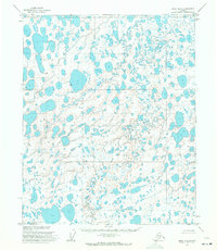
1955 Map of Umiat D-5
USGS Topo · Published 1971About this map
The vast, thaw-lake-studded landscape of the Arctic Coastal Plain dominates this 1955 survey of the Naval Petroleum Reserve No. 4. This remote region, mapped by the U. S. Army Topographic Command, reveals an intricate network of wandering waterways and hundreds of unnamed basins characteristic of permafrost terrain. The primary drainage is Judy Creek, which meanders through the northeast corner of the sheet, while specific relief features are identified by short names such as Maria, Bali, Olive, and Naran. These points represent subtle topographic variations in an otherwise nearly level expanse of tundra. The map underscores the early federal interest in northern energy resources, documenting a territory that remained largely unsurveyed on the ground, with land lines predetermined by the Bureau of Land Management but not yet marked in the field.
Find a feature on this map
6 named features on this map. Tap any name to fly to it.
Don’t see what you’re looking for? This feature index may not catch every label — zoom into the map to look around manually.
Map Details
Editions of this 1955 Umiat D-5 Map
This is the sole edition of this map. No revisions or reprints were ever made.
Other maps of this area

1951 · Harrison Bay
USGS Topo · 1:250,000

1951 · Teshekpuk
USGS Topo · 1:250,000

1951 · Ikpikpuk River
USGS Topo · 1:250,000

1952 · Umiat
USGS Topo · 1:250,000

1955 · Harrison Bay
USGS Topo · 1:250,000

1955 · Teshekpuk
USGS Topo · 1:250,000

1955 · Harrison Bay A-4
USGS Topo · 1:63,360

1955 · Teshekpuk A-1
USGS Topo · 1:63,360

1955 · Harrison Bay A-5
USGS Topo · 1:63,360

1955 · Umiat C-4
USGS Topo · 1:63,360