
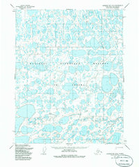
1955 Map of Harrison Bay B-5
USGS Topo · Published 1968About this map
The Kalikpik River winds through a vast network of unnamed lakes and marshland on the North Slope of Alaska, as documented in 1955. This remote landscape within the former Naval Petroleum Reserve No. 4 is characterized by its high density of thermokarst lakes, which dominate the surface drainage patterns across the tundra. The only evidence of human passage through this frozen landscape is a mapped Winter Trail that cuts across the northeastern portion of the quadrangle. Mapped primarily through photogrammetric methods by the Army Map Service, the sheet records the intricate hydrography of the region before modern industrial developments shifted the footprint of the Arctic wilderness. The absence of permanent settlements or named landmarks highlights the seasonal nature of travel and the environmental constraints of the coastal plain during the mid-20th century.
Find a feature on this map
2 named features on this map. Tap any name to fly to it.
Don’t see what you’re looking for? This feature index may not catch every label — zoom into the map to look around manually.
Map Details
Editions of this 1955 Harrison Bay B-5 Map
2 editions found
Other maps of this area

1951 · Harrison Bay
USGS Topo · 1:250,000

1951 · Teshekpuk
USGS Topo · 1:250,000

1955 · Harrison Bay
USGS Topo · 1:250,000

1955 · Teshekpuk
USGS Topo · 1:250,000

1955 · Harrison Bay A-4
USGS Topo · 1:63,360

1955 · Teshekpuk A-1
USGS Topo · 1:63,360

1955 · Teshekpuk B-1
USGS Topo · 1:63,360

1955 · Harrison Bay C-5
USGS Topo · 1:63,360

1955 · Harrison Bay A-5
USGS Topo · 1:63,360

1955 · Harrison Bay C-4
USGS Topo · 1:63,360