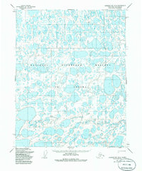
1955 Map of Harrison Bay B-5
USGS Topo · Published 1985About this map
The National Petroleum Reserve in Alaska dominates this 1955 survey of the North Slope, revealing a landscape defined by an intricate network of lakes and tundra. The Kalikpik River winds through the central and southern portions of the sheet, providing a primary hydrological feature in an otherwise water-saturated environment. Human activity is sparse but specialized, evidenced by the presence of a Drill Hole and isolated Cabins that speak to the region's mid-century petroleum exploration efforts. Navigation across this remote terrain relied on the Winter Trail, a crucial seasonal route through the northern section. While larger settlements are absent, the map identifies small, localized sites like Leona, which likely served as temporary camps or survey points during the Defense Mapping Agency's photogrammetric projects.
Find a feature on this map
6 named features on this map. Tap any name to fly to it.
Don’t see what you’re looking for? This feature index may not catch every label — zoom into the map to look around manually.
Map Details
Editions of this 1955 Harrison Bay B-5 Map
2 editions found
Other maps of this area

1951 · Harrison Bay
USGS Topo · 1:250,000

1951 · Teshekpuk
USGS Topo · 1:250,000

1955 · Harrison Bay
USGS Topo · 1:250,000

1955 · Teshekpuk
USGS Topo · 1:250,000

1955 · Harrison Bay A-4
USGS Topo · 1:63,360

1955 · Teshekpuk A-1
USGS Topo · 1:63,360

1955 · Teshekpuk B-1
USGS Topo · 1:63,360

1955 · Harrison Bay C-5
USGS Topo · 1:63,360

1955 · Harrison Bay B-5
USGS Topo · 1:63,360

1955 · Harrison Bay A-5
USGS Topo · 1:63,360