
1955 Map of Teshekpuk B-1
USGS Topo · Published 1965About this map
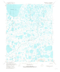
The southeast reaches of Teshekpuk Lake dominate the northwestern corner of this mid-century survey, situated within the bounds of Naval Petroleum Reserve No. 4. The landscape is a complex mosaic of thermokarst lakes and meandering waterways, most notably the winding path of Kealok Creek as it drains northward. Human presence is sparse, marked by small outposts like Field Camp and Audrey, which suggest the era's focus on geological and petroleum exploration in the Arctic. To the south, the Pik Dunes provide a distinct contrast to the water-saturated tundra. Movement across this thawing ground is evidenced by a network of paths, including a designated Tractor Trail and a more general Trail, showing how surveyors and explorers navigated the North Slope before more permanent infrastructure arrived.
Find a feature on this map
7 named features on this map. Tap any name to fly to it.
Don’t see what you’re looking for? This feature index may not catch every label — zoom into the map to look around manually.
Map Details
Editions of this 1955 Teshekpuk B-1 Map
2 editions found
Other maps of this area

1951 · Harrison Bay
USGS Topo · 1:250,000

1951 · Teshekpuk
USGS Topo · 1:250,000

1955 · Harrison Bay
USGS Topo · 1:250,000

1955 · Teshekpuk
USGS Topo · 1:250,000
1955 · Teshekpuk A-2
USGS Topo · 1:63,360

1955 · Teshekpuk A-1
USGS Topo · 1:63,360
1955 · Teshekpuk B-2
USGS Topo · 1:63,360

1955 · Harrison Bay C-5
USGS Topo · 1:63,360

1955 · Harrison Bay B-5
USGS Topo · 1:63,360

1955 · Harrison Bay A-5
USGS Topo · 1:63,360