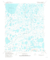
1955 Map of Teshekpuk B-1
USGS Topo · Published 1980About this map
Teshekpuk Lake dominates the northwest corner of this 1955 survey of Alaska's North Slope, a landscape defined by an intricate network of thaw lakes and the meandering course of Kealok Creek. The terrain reveals the logistical footprint of mid-century Arctic exploration within the National Petroleum Reserve, marked by a Tractor Trail and a primary Field Camp. Small named locations such as Olak, Aval, and Audrey punctuate the tundra, likely serving as survey benchmarks or temporary outposts during the photogrammetric mapping process by the Army Map Service. In the south, the Pik Dunes provide a distinct topographic contrast to the surrounding marshy lowlands. This map captures the region in a transitional period of geological study, documenting remote sites like Dim and Iris before later industrial shifts altered the surface of the North Slope.
Find a feature on this map
11 named features on this map. Tap any name to fly to it.
Don’t see what you’re looking for? This feature index may not catch every label — zoom into the map to look around manually.
Map Details
Editions of this 1955 Teshekpuk B-1 Map
2 editions found
Other maps of this area

1951 · Harrison Bay
USGS Topo · 1:250,000

1951 · Teshekpuk
USGS Topo · 1:250,000

1955 · Harrison Bay
USGS Topo · 1:250,000

1955 · Teshekpuk
USGS Topo · 1:250,000
1955 · Teshekpuk A-2
USGS Topo · 1:63,360

1955 · Teshekpuk A-1
USGS Topo · 1:63,360
1955 · Teshekpuk B-2
USGS Topo · 1:63,360

1955 · Teshekpuk B-1
USGS Topo · 1:63,360

1955 · Harrison Bay C-5
USGS Topo · 1:63,360

1955 · Harrison Bay B-5
USGS Topo · 1:63,360