
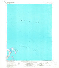
1955 Map of Harrison Bay B-4
USGS Topo · Published 1970About this map
The Harrison Bay coastline meets a complex network of thaw lakes and meandering waterways in this 1955 survey of Alaska's North Slope. The landscape is defined by the wandering paths of the Kalikpik River and Fish Creek, which snake through a tundra environment dominated by hundreds of unnamed water bodies. This specific area was of significant strategic and industrial interest during the mid-20th century, as it is situated entirely within Naval Petroleum Reserve No. 4. A notable marker of early resource exploration is the Fish Creek Test Well No 1 (Site) located in the southeastern portion of the map. Movement across this saturated terrain was seasonal, indicated by the presence of a Winter Trail that cuts across the lakes, providing a glimpse into the logistics of Arctic surveying and energy prospecting before more permanent infrastructure arrived.
Find a feature on this map
7 named features on this map. Tap any name to fly to it.
Don’t see what you’re looking for? This feature index may not catch every label — zoom into the map to look around manually.
Map Details
Editions of this 1955 Harrison Bay B-4 Map
This is the sole edition of this map. No revisions or reprints were ever made.
Other maps of this area

1951 · Harrison Bay
USGS Topo · 1:250,000

1955 · Harrison Bay
USGS Topo · 1:250,000

1955 · Harrison Bay A-4
USGS Topo · 1:63,360

1955 · Harrison Bay B-3
USGS Topo · 1:63,360
1955 · Harrison Bay C-3
USGS Topo · 1:63,360

1955 · Harrison Bay C-5
USGS Topo · 1:63,360

1955 · Harrison Bay B-5
USGS Topo · 1:63,360

1955 · Harrison Bay A-5
USGS Topo · 1:63,360

1955 · Harrison Bay A-3
USGS Topo · 1:63,360

1955 · Harrison Bay C-4
USGS Topo · 1:63,360