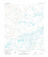
1971 Map of Umiat C-1
USGS Topo · Published 1973About this map
The Kuparuk River dominates this Arctic landscape, its meandering channels and oxbow lakes creating a complex hydrological network through the permafrost. The terrain is characterized by a high density of thaw lakes and marshes, interspersed with a distinct Pingo, a characteristic ice-cored mound that serves as a rare point of elevation in the wet tundra. A long-distance Winter Trail cuts across the northern and eastern sections of the quadrangle, indicating the seasonal movement patterns required in this environment before permanent road infrastructure. The map reflects a moment in 1970 when the Bureau of Land Management was predetermining land lines for these unsurveyed regions of the Umiat Meridian, capturing the raw state of the North Slope just as modern exploration began to intensify in the region.
Find a feature on this map
3 named features on this map. Tap any name to fly to it.
Don’t see what you’re looking for? This feature index may not catch every label — zoom into the map to look around manually.
Map Details
Editions of this 1971 Umiat C-1 Map
This is the sole edition of this map. No revisions or reprints were ever made.
Other maps of this area

1951 · Sagavanirktok D-5
USGS Topo · 1:250,000

1952 · Umiat
USGS Topo · 1:250,000

1955 · Umiat D-2
USGS Topo · 1:63,360
1955 · Sagavanirktok D-5
USGS Topo · 1:63,360
1955 · Umiat D-1
USGS Topo · 1:63,360

1956 · Sagavanirktok
USGS Topo · 1:250,000

1956 · Umiat
USGS Topo · 1:250,000

1958 · Sagavanirktok
USGS Topo · 1:250,000

1964 · Umiat
USGS Topo · 1:250,000

1964 · Sagavanirktok
USGS Topo · 1:250,000