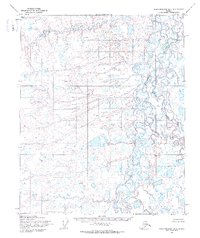
1955 Map of Sagavanirktok D-5
USGS Topo · Published 1970About this map
Braided river systems dominate this northern landscape, captured by U.S. Geological Survey photogrammetry in the mid-1950s. The wide, shifting channels of the Kuparuk River flow northward across the tundra, characterized by complex meanders and numerous oxbow lakes. Toward the eastern edge of the quadrangle, the Toolik River joins the drainage network, navigating a terrain densely pocketed with small thaw lakes and marshy depressions. This survey records the natural state of the North Slope before industrial development, showing an environment defined entirely by its hydrological patterns and the absence of any established roads or permanent settlements at the time of the 1955 field annotation.
Find a feature on this map
2 named features on this map. Tap any name to fly to it.
Don’t see what you’re looking for? This feature index may not catch every label — zoom into the map to look around manually.
Map Details
Editions of this 1955 Sagavanirktok D-5 Map
2 editions found
Other maps of this area

1951 · Harrison Bay
USGS Topo · 1:250,000

1951 · Beechey Point
USGS Topo · 1:250,000

1951 · Sagavanirktok D-5
USGS Topo · 1:250,000

1952 · Umiat
USGS Topo · 1:250,000

1955 · Harrison Bay
USGS Topo · 1:250,000

1955 · Beechey Point
USGS Topo · 1:250,000

1955 · Beechey Point A-5
USGS Topo · 1:63,360

1955 · Beechey Point A-4
USGS Topo · 1:63,360

1955 · Sagavanirktok D-4
USGS Topo · 1:63,360
1955 · Harrison Bay A-1
USGS Topo · 1:63,360