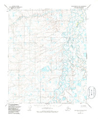
1955 Map of Sagavanirktok D-5
USGS Topo · Published 1986About this map
The Kuparuk River winds through this expanse of the North Slope, revealing a landscape defined by braided waterways and thermokarst lakes as they appeared in 1955. This area, later revised in 1985, serves as a record of the terrain prior to the full development of the region's petroleum infrastructure. A single Drill Hole is noted amongst the vast network of small ponds and marshes, signifying early exploration efforts in the Arctic tundra. The geography is further marked by the Toolik River, which joins the larger Kuparuk system in the northern portion of the quadrangle. Named local landmarks such as Rubar and Nello provide specific reference points for researchers studying the historical topography and surveying of this remote Alaskan borough.
Find a feature on this map
5 named features on this map. Tap any name to fly to it.
Don’t see what you’re looking for? This feature index may not catch every label — zoom into the map to look around manually.
Map Details
Editions of this 1955 Sagavanirktok D-5 Map
2 editions found
Other maps of this area

1951 · Harrison Bay
USGS Topo · 1:250,000

1951 · Beechey Point
USGS Topo · 1:250,000

1951 · Sagavanirktok D-5
USGS Topo · 1:250,000

1952 · Umiat
USGS Topo · 1:250,000

1955 · Harrison Bay
USGS Topo · 1:250,000

1955 · Beechey Point
USGS Topo · 1:250,000

1955 · Beechey Point A-5
USGS Topo · 1:63,360

1955 · Beechey Point A-4
USGS Topo · 1:63,360
1955 · Sagavanirktok D-5
USGS Topo · 1:63,360

1955 · Sagavanirktok D-4
USGS Topo · 1:63,360