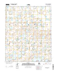
2013 Map of Umiat D-4 NW
USGS Topo · Published 2013About this map
Glacial thermokarst lakes and intricate wetland complexes dominate this remote Arctic terrain within the North Slope Borough. Located in the northern reaches of the state, the landscape is defined by the Public Land Survey System boundaries of T 8 N T 7 N and T 7 N T 6 N, marking the transition between township grids. The surface is a dense mosaic of thaw lakes and ponds, typical of the permafrost-underlain coastal plain, where drainage patterns are often indistinct and dictated by subtle topographical variations. This survey provides a precise look at the hydrology and land divisions between R 2 W R 1 W as they existed in the early twenty-first century.
Find a feature on this map
3 named features on this map. Tap any name to fly to it.
Don’t see what you’re looking for? This feature index may not catch every label — zoom into the map to look around manually.
Map Details
Editions of this 2013 Umiat D-4 NW Map
This is the sole edition of this map. No revisions or reprints were ever made.
Other maps of this area

1951 · Harrison Bay
USGS Topo · 1:250,000

1952 · Umiat
USGS Topo · 1:250,000

1955 · Harrison Bay
USGS Topo · 1:250,000

1955 · Harrison Bay A-4
USGS Topo · 1:63,360

1955 · Harrison Bay A-5
USGS Topo · 1:63,360
1955 · Umiat D-5
USGS Topo · 1:63,360
1955 · Umiat D-4
USGS Topo · 1:63,360

1956 · Umiat
USGS Topo · 1:250,000

1964 · Umiat
USGS Topo · 1:250,000
2013 · Umiat D-4 SE
USGS Topo · 1:25,000