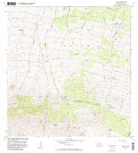
1982 Map of Umikoa
USGS Topo · Published 1982About this map
The mountain slopes of Hawaii's northern coast are defined by the sprawling acreage of Umikoa (Kukaiau Ranch) and vast protected lands. This high-elevation terrain is segmented by numerous gulches, such as Kukaiau Gulch and Hanaipoe Gulch, which drop away from the steep cinder cones that dominate the skyline. Several prominent volcanic peaks, or pu'u, are mapped here including Puu Mali, Puu Ulaula, and the notable Iolehaehae.
Find a feature on this map
40 named features on this map. Tap any name to fly to it.
Don’t see what you’re looking for? This feature index may not catch every label — zoom into the map to look around manually.
Map Details
Editions of this 1982 Umikoa Map
2 editions found
Other maps of this area

1915 · Hamakua
USGS Topo · 1:62,500

1916 · Waipio
USGS Topo · 1:62,500

1954 · Hawaii North
USGS Topo · 1:250,000

1956 · Pua Akala
USGS Topo · 1:24,000

1956 · Keanakolu
USGS Topo · 1:24,000

1956 · Makahalau
USGS Topo · 1:24,000
1956 · Ahumoa
USGS Topo · 1:24,000

1956 · Mauna Kea
USGS Topo · 1:24,000

1956 · Umikoa
USGS Topo · 1:24,000

1957 · Kukaiau
USGS Topo · 1:24,000