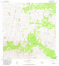
1982 Map of Umikoa
USGS Topo · Published 1982About this map
Umikoa (Kukaiau Ranch) sits at the northeastern edge of this high-elevation landscape, where the transition from managed ranching land to the protected wilderness of the Hamakua Forest Reserve is clearly defined. This 1982 map illustrates the complex upland geography of Hawaii’s Big Island, dominated by a series of volcanic cinder cones and gulches that descend from the upper slopes of Mauna Kea. Notable peaks like Puu Mali, Puu Kea, and Iolehaehae punctuate the terrain, which is divided by the significant Rock Wall Forest Reserve Boundary separating private ranch land from the Mauna Kea Forest Reserve. Access across this demanding environment is primarily facilitated by the Keanakolu Road. The presence of several former habitation areas, such as the Waikamakapo (Site) and Hanaipoe, indicates a history of land use and temporary settlement in these high pastures and forest fringes.
Find a feature on this map
45 named features on this map. Tap any name to fly to it.
Don’t see what you’re looking for? This feature index may not catch every label — zoom into the map to look around manually.
Map Details
Editions of this 1982 Umikoa Map
2 editions found
Other maps of this area

1915 · Hamakua
USGS Topo · 1:62,500

1916 · Waipio
USGS Topo · 1:62,500

1954 · Hawaii North
USGS Topo · 1:250,000

1956 · Pua Akala
USGS Topo · 1:24,000

1956 · Keanakolu
USGS Topo · 1:24,000

1956 · Makahalau
USGS Topo · 1:24,000
1956 · Ahumoa
USGS Topo · 1:24,000

1956 · Mauna Kea
USGS Topo · 1:24,000

1956 · Umikoa
USGS Topo · 1:24,000

1957 · Kukaiau
USGS Topo · 1:24,000