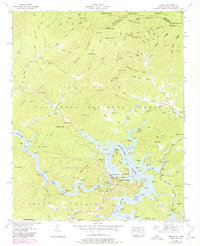
1957 Map of Unaka
USGS Topo · Published 1978About this map
The Hiwassee River winds through the heart of this landscape, its waters slowed and expanded by the massive Hiwassee Dam and the downstream reach of Apalachia Lake. This borderland between North Carolina and Tennessee is defined by the sharp ridges of the Unicoi Mountains, where the Joe Brown Highway snakes through the high gaps. Small settlements like Unaka and Ogreeta are situated near the fingers of Hiwassee Lake, reflecting the intersection of hydroelectric development and rural Appalachian life. Genealogists and local historians will find numerous family-named landmarks and institutions, including Reids Chapel, New Hope Ch, and the Violet Cem. From the timbered slopes of Lead Mountain to the industry at Hyatt Mill, the map documents a region of transition where public lands like the Nantahala National Forest meet the evolving shoreline of the Tennessee Valley Authority's reservoir system.
Find a feature on this map
84 named features on this map. Tap any name to fly to it.
Don’t see what you’re looking for? This feature index may not catch every label — zoom into the map to look around manually.
Map Details
Editions of this 1957 Unaka Map
3 editions found
Other maps of this area

1893 · Murphy
USGS Topo · 1:125,000

1914 · Murphy
USGS Topo · 1:125,000

1927 · Big Junction
USGS Topo · 1:24,000

1933 · Haw Knob
USGS Topo · 1:48,000

1933 · Bald River Falls
USGS Topo · 1:24,000

1934 · Murphy
USGS Topo · 1:24,000

1934 · Persimmon Creek
USGS Topo · 1:24,000

1934 · McDaniel Bald
USGS Topo · 1:24,000

1934 · Unaka
USGS Topo · 1:24,000

1934 · Murphy
USGS Topo · 1:48,000