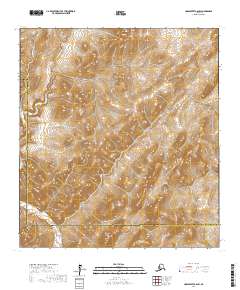
2017 Map of Unalakleet A-6 SW
USGS Topo · Published 2017About this map
Nulato Hills dominate the interior landscape of this region along the border of the Nome Census Area and the Kusilvak Census Area. The terrain is defined by the winding course of the Andreafsky River, which flows through the western portion of the quadrangle. This 2017 survey by the U.S. Geological Survey illustrates a remote stretch of the Alaskan wilderness where natural topography and hydrography are the primary features, with no modern road networks or settlements present. The map provides precise elevation contours for the ridges and valleys of the hills, offering a clear view of the drainage patterns that feed into the river system during this period of the twenty-first century.
Find a feature on this map
10 named features on this map. Tap any name to fly to it.
Don’t see what you’re looking for? This feature index may not catch every label — zoom into the map to look around manually.
Map Details
Editions of this 2017 Unalakleet A-6 SW Map
This is the sole edition of this map. No revisions or reprints were ever made.
Other maps of this area

1951 · Unalakleet
USGS Topo · 1:250,000

1951 · St Michael
USGS Topo · 1:250,000

1951 · Holy Cross
USGS Topo · 1:250,000

1952 · Kwiguk
USGS Topo · 1:250,000

1952 · Kwiguk D-1
USGS Topo · 1:63,360

1952 · Saint Michael A-1
USGS Topo · 1:63,360

1952 · Unalakleet A-6
USGS Topo · 1:63,360
1952 · Holy Cross D-6
USGS Topo · 1:63,360

1952 · St Michael
USGS Topo · 1:250,000

1952 · Unalakleet
USGS Topo · 1:250,000