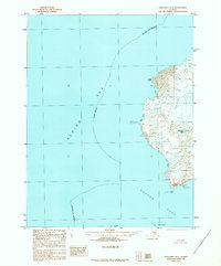
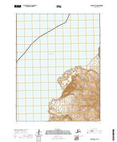
1989 Map of Unalaska D-1
USGS Topo · Published 1989About this map
Akutan Island dominates this 1980s topographic record, showcasing the volcanic terrain of the eastern Aleutians. The western coastline is defined by a series of dramatic indentations including Lava Bight, Reef Bight, and Flat Bight, where the land meets the Bering Sea. Interior elevations are marked by prominent landmarks such as Flat Top Peak, while the southern tip of the island terminates at Cape Morgan and the nearby Triplet Rocks. Across the water, the Baby Islands sit within the narrow Baby Pass, separating Akutan from the neighboring Unalga Island. The map illustrates a landscape devoid of roads or trails, reflecting the preservation of the maritime wilderness within the Aleutians East Borough.
Find a feature on this map
20 named features on this map. Tap any name to fly to it.
Don’t see what you’re looking for? This feature index may not catch every label — zoom into the map to look around manually.
Map Details
Editions of this 1989 Unalaska D-1 Map
This is the sole edition of this map. No revisions or reprints were ever made.
Other maps of this area

1951 · Unalaska
USGS Topo · 1:250,000

1951 · Unimak
USGS Topo · 1:250,000

1958 · Unimak
USGS Topo · 1:250,000

1989 · Unimak A-6
USGS Topo · 1:63,360
1989 · Unimak B-6
USGS Topo · 1:63,360
1989 · Unalaska D-2
USGS Topo · 1:63,360
1989 · Unalaska C-1
USGS Topo · 1:63,360

1990 · Unalaska C-2
USGS Topo · 1:63,360

2020 · Unalaska D-1 SW
USGS Topo · 1:25,000
2020 · Unalaska D-1 NE
USGS Topo · 1:25,000