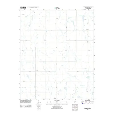
2012 Map of Unap Mountain
USGS Topo · Published 2012About this map
Unap Mtn and Rainy Mtn anchor this Kiowa County landscape, where the plains of southwestern Oklahoma are defined by a managed water system and a strict sectional road grid. The small settlement of Sedan sits at the intersection of e1410 RD and n2370 RD, serving as a focal point in a territory largely devoted to ranching and agriculture. A series of water management projects are evident across the drainage basins of Rainy Mountain Cr, Sugar Cr, and Longhorn Cr, including numerous catchment areas such as Rainy Mountain Cr Site 4 Reservoir and Rainy Mountain Cr Site 13 Reservoir. Local history and genealogy are preserved at the Union Dale Cem in the southwestern quadrant, while the Jennings Ranch Airport reflects the continued importance of private aviation for large-scale land management in this region.
Find a feature on this map
29 named features on this map. Tap any name to fly to it.
Don’t see what you’re looking for? This feature index may not catch every label — zoom into the map to look around manually.
Map Details
Editions of this 2012 Unap Mountain Map
This is the sole edition of this map. No revisions or reprints were ever made.
Other maps of this area

1949 · Cooperton
USGS Topo · 1:62,500

1950 · Saddle Mountain
USGS Topo · 1:62,500

1955 · Lawton
USGS Topo · 1:250,000

1955 · Clinton
USGS Topo · 1:250,000

1956 · Glen Mountains
USGS Topo · 1:24,000

1956 · Saddle Mountain
USGS Topo · 1:24,000

1956 · Cooperton
USGS Topo · 1:24,000

1956 · Bally Mountain
USGS Topo · 1:24,000

1956 · Unap Mountain
USGS Topo · 1:24,000

1956 · Rainy Mountain Creek
USGS Topo · 1:24,000